Itinerary
The Chopta-Chandrashila Trek is one of the most captivating treks in India that takes you through the stunning winter landscapes of the Garhwal region in Uttarakhand, India. This trek is renowned for its stunning vistas, spiritual significance, and challenging yet rewarding nature. It combines the charm of Deoriatal, the beauty of Chopta, and the spiritual aura of Tungnath and Chandrashila. The trek begins near Sari village, passes through Chopta, Tungnath, and culminates at Chandrashila Peak. During winter, trekkers are rewarded with snow-covered landscapes and the opportunity to witness the Chopta regions ethereal beauty.
Day 1 : Rishikesh - Sari Village
- Altitude Sari 2,000m/6,550ft.
- Drive 190 km | 7 hr.
- Trekkers will be picked up at 6:00 am from Trail Trecker India Head office (Tapovan) in a Tata Sumo/Tempo Traveller or a similar vehicle (cost is not included).
- Breakfast and Lunch on the way (exclusive of charges).
- Arrive at Sari Village by approx. 4 pm – (tea, briefing of the trek & dinner).
- No local market.
- Telephone Network- Available.
- Stay in the guest house.
The journey to Chopta commences at Rishikesh, where our representatives will pick you up from the Rishikesh Trail Trecker India Head office (Tapovan). You will be driven to Sari, which is the base for the Deoriatal trek and is about a 7-hour drive away from Rishikesh. En route Sari, you will pass a holy confluence at Devprayag, one of the five prayags. This is a sacred site for the Hindus as it sees the confluence of two rivers Alakananda and Bhagirathi. As you traverse along the mountain road, the river keeps you company all along the way and you will also enjoy captivating views of the lower Garhwal Himalayas.
The Sari village is a small mountain settlement with about 100 houses lined on the mountains and many beautiful paddy fields enhancing its natural beauty. Sari offers stunning meadow views and the people here are warm and friendly. You will also get the first glimpses of the Chandrashila summit from here.
Day 2 : Trek From Sari To Alpine Lake Deoriatal
- Altitude: Deoriatal 2,400m/7,850 ft.
- Trek: 3km | 1hr.
- Altitude Gain:- 400m/ 1,300ft
- Steep ascent till the campsite.
- Well marked trail through pine and oak forest.
- Water source-None.
- Hot lunch at campsite.
- Go to Deoriatal lake for an evening walk.
- Deoriatal lake is 10 minutes walk from campsite.
- Stay in Tent - dome tent (Twin sharing) and swiss tent (triple/quad sharing).
Today is the first day of your adventure and you will trek from Sari to Deoriatal. It is a very short trek of about 3 km that takes you to Deoriatal. The trek to Deoriatal is quite easy with mixed ascents and descents along the way.
From Sari follow the well-defined rocky trail that gradually climbs up the mountains. Keep walking on the trail and after 30 minutes, you will come across your first major viewpoint. Stop for a while and treat your eyes to alluring views of mountains and valleys. Treading further along the trail, you will come across a forest of maple and Rhododendron. If you visit during the spring, the Rhododendrons will be red and blooming a beautiful visual treat. Another hour or so and you arrive at Deoriatal.
Deoriatal provides the perfect dreamy setting for camping. The lovely alpine lake is nestled beautifully in a mountain clearing and is surrounded on all sides by the majestic Garhwal Himalayas. Mt. Chaukhamba is the most prominent here and it casts its reflection on the lake waters, a surreal sight to behold. Wait until morning when the mist lifts and the sun rays warm up the peaks in a golden glow. The snow-clad mountains in the backdrop with the lake taking center-stage, it is the perfect place to capture some Instagram-worthy shots.
From the trail, you can spot the Chandrashila summit and below it, the Tungnath temple, which is just a speck in the mountains and you may need binoculars to spot the temple. Deoriatal is also a Green-Trail hotspot and you are going to find a lot of litter around the campsites, keep your eco bags ready to collect the garbage.
Reaching Deoriatal, we will set out tents for the night and a hot lunch and dinner will be provided at the campsite. You will have almost an entire day in your hand that you can use to explore the area and acclimatize as well. This is also a popular site for birdwatching and you may even spot some rare Himalayan birds. Explore the trails around the campsite and let the tranquillity of the mountains slowly engulf you.
Day 3 : Trek From Deoriatal To Baniyakund via Rohini Bugyal
- Altitude: Banuyakund 2,600m/ 8,550ft
- Trek: 16km | 8hr
- Drive: 3km | 10min
- Altitude Gain:- 200m/ 700ft
- Water source- A groundwater source before entering Rohini Bugyal. Waterfalls on the second half of the trail.
- Gradual ascent on a meadow.
- Packed lunch for the way.
- Drive Sari village to Baniyakund: 23km | 45min.
- If unable to do 16 km trek then can come back to Sari village by trek and drive to Baniyakund campsite, if Trail Trecker India vehicle is available then drive from Sari to Baniyakund is free and if not then trekkers will have to pay around Rs 1200.
- Stay in Cottages/ Swiss Camp (triple/quad/dormitory).
Today is the most scenic day of your trek and a treat for all nature lovers. Today’s trail is made spectacular with the Rhododendron covers that become denser and denser as you trek uphill. The Kedar dome and the Chaukhamba peaks also peek through the tree covers. You will spot two varieties of Rhododendrons here, red and pink and during the months of March and April, the trail is set ablaze in hues of crimson. The forest cover soon opens into a beautiful clearing, the Rohini Bugyal meadow which is lined with Rhododendrons on all sides.
The trek today is moderate starting with a gradual ascent followed by a slight descent, which eases to a gradual ascent until Rohini Bugyal. From Rohini Bugyal there’s a steep descent followed by a mix of ascents and descents to Baniyakund. As the Rhododendron cover clears up, you will get clear views of Chandrashila Peak in the distance, and on your right below, you can see the Sari village once again.
The trail passes through Kedarnath Sanctuary, so you may be able to spot some Himalayan Wildlife like red foxes and other small animal species and birds like Griffon Vultures, which are huge birds of prey as well as Verditer Flycatcher and Himalayan Woodpecker. Every now and then, you may also come across small shrines with prayer flags tied to them. These temples are built by the locals. Walk for 20 more minutes and you will reach a landmark temple, the Bagdwal temple and you will spot three paths branching out.
One route connects back to Sari village, another connects to Ukhimath and there’s a third descending path, which leads us to Rohini Bugyal. The Chandrashila and Kala Parvat become quite prominent from here. Walk for about 30 minutes and you will pass a small rivulet. This is your water source and you can fill your bottles here. Tread across a wooden bridge to cross the river and a small uphill climb will lead you to Rohini Bugyal.
As you climb uphill from Rohini Bugyal, the views get better and better and you will observe a series of shepherd huts lining the hills. During the summer months, the locals occupy these huts along with their livestock. The Rohini Bugyal meadows provide the perfect spot for cattle grazing. From here, crossing a few gradual ascents, you will reach Baniyakund. Further ahead, there is a motorable road that leads to Chopta, and from here take the trail on the right to reach the Baniyakund campsite, a clearing between the forests. You will stay overnight in Cottages/ Camp.
Day 4 : Summit Day: Drive From Baniyakund to Chopta and Trek to Tungnath & Chandrashila, Return to Baniyakund
- Altitude: Chandrashilla top 3,700m/ 12,100 ft.
- Altitude: Tungnath 3450m/ 11,380ft.
- Altitude: Chopta 2,850m/ 9,400ft.
- Trek: 9km | 7hr (Both side).
- Buniyakund to Chopta (Drive 3km | 10min).
- Chopta to Tungnath 3.5km |3hr.
- Tungnath to Chandrashilla Summit 1km | 1hr.
- Trek: Gradual ascent.
- Packed lunch for the day.
- Water Source- None.
- Tungnath is the highest Shiva temple.
- View: Mountains of Garhwal and Kumaon- Nanda Devi, Trishul, Nandaghunti, Dronagiri, Chaukhamba, Kedar dome, Thalaysagar, Gangotri ranges, Jahanukut etc.
- Stay in Cottages/ Swiss Camp (triple/quad/dormitory).
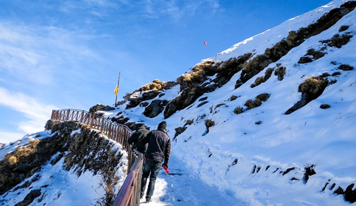
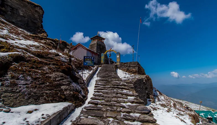
Today is the summit day and we will have an early start at the wee hours before sunrise so that we can catch the sunrise from Tungnath. The path from Chopta to Tungnath wades along a well-defined, concrete trail. The trek from Chopta to Tungnath is about 3 km and the trail entwines along meadows and forests before making way to the Tungnath temple and 1.5 km from Tungnath lies Chandrashila summit. The trail remains buried deep in snow during the winters adding to the challenge of the climb to Chandrashila from Tungnath, which is already quite steep.
The trail from Chopta to Tungnath is well-defined which makes it quite accessible but at the same time, it is a little steep with numerous scissor bends. As you make your way to the second last scissor bend, you can see the Tungnath temple on the right and the Chandrashila summit. The views start getting increasingly better from here and Tungnath Temple is just half a kilometer away. On the left is a view overlooking a valley of Birch trees, which is again a prime spot to sight bird species like Monal and Griffon Vultures.
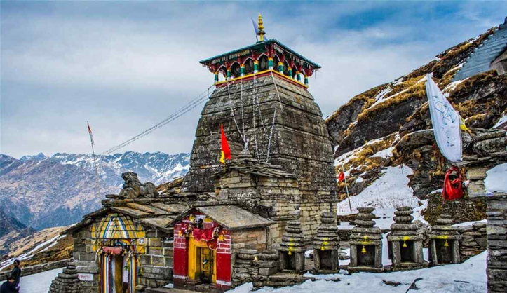
Soon you will reach the Tungnath temple, which remains closed in winter and you will find snow until April here. The Tungnath Temple is one of the Panch Kedars and is steeped in mythology and folklore. The legend according to Mahabharata goes that the Panch Kedars was built by the Pandavas, asking for Lord Shiva’s forgiveness and atonement of their sins incurred by killing their kins in the battle of Kurukshetra. Lord Shiva appeared in a bull form and parts of the bull appeared in these five locations, where the shrines were built. Tungnath is where the limbs and chest of the bull appeared.
From Tungnath temple, the trek to the Chandrashila summit is a short but challenging one as it is pretty steep. Crampons and gaiters are a must if you are attempting this trek in the winter. Follow your trek leaders instructions to safely make it to the summit. The trail to Chandrashila starts just behind the temple complex. You ascend 600 ft from Tungnath conquering a very steep climb. Once you reach the Chandrashila Base, the Chandrashila peak becomes visible and another 30 to 45 minutes climb takes you to the summit, where you will get some epic mountain views including Mt. Trishul, Nanda Ghunti, Nanda Devi, Thalaysagar, Gangotri Ranges, Kamet, Chaukhamba, Kedar Dome, Dunagiri, Jahanukut and more.
Day 5 : Departure To Rishikesh
- Drive 210 km (7 hrs drive)
- Reach Rishikesh by 5:00 pm
- Trekkers will be dropped at Trail Trecker India Head office (Tapovan) in a Tata Sumo/Tempo Traveller or a similar vehicle (cost is not included)
- After morning tea move to Rishikesh (breakfast and lunch on the way, exclusive of charges)
This is the last day of your journey, where we will drop you off at Rishikesh. Board your vehicles at Baniyakund and its a 7-hour drive to Rishikesh, along the same mountain roads you came in, taking back with you warm memories of the mountains. We will drop you off at Rishikesh by 6:30 PM and you can book your further journey onwards.
DAY 06 Chilurgad to Sankri Via Takula
- 12 Km trek, 12 Km Drive
Wake up early in the morning and freshen up for the day ahead.
Trek after breakfast.
Reach Taluka in the afternoon then drive to Sankri.
Rest in the hotel in Sankri.
Dinner followed by rest
DAY 07 Sankri to Dehradun
- 190 Km drive, 7-8 hours
Leave Sankri after breakfast
Har ki dun certificate ceremony
Arrival at Dehradun by 6:00 PM.
Who Can Participate
- Age; 10 years.
- First timer can apply; previous trekking experience is more appreciated.
- The climber must be fit and have sufficient stamina to cover 4 km of distance in 30 minutes without a stress.
- The climber should be able to carry a 10-15 kg backpack.
Health Awareness
- Pulse rate at rest must be in between (60 to 90 beats per minute)
- Blood Pressure Reading must be in between (DIASTOLIC 75 – 85, SYSTOLIC 100 - 130 mm Hg)
- Respiratory rate at rest must be in between (12 to 20 breaths per minute)
- Should not have Liver and kidney issues
- Should not have Diabetes Mellitus, Bronchial Asthma, Epilepsy, Heart problems, Hypertension etc
- No pacemaker implant
- People with the Sinus issues please contact to trek coordinator before booking the trek
- If your BMI is not normal, Please contact our Trek coordinator before Trek booking.
Cost Terms
Inclusions
1. Accommodation. (Guest house - Triple/quad/penta sharing, Camping - twin sharing)
2. Meals while on trek (Veg.+ occasional Egg): Day 1 Dinner to Day 5 Dinner as per the itinerary, Drinking water while on trek (Tape/Mountain water).
3. Trek equipment: Sleeping bag, mattress, tent (twin sharing), kitchen & dining tent, toilet tent, utensils, and crampon (if required)
4. All necessary permits and entry fees.
5. First aid medical kits, stretcher, and oxygen cylinder.
6. Mountaineering qualified & professional trek Leader, guide, and Support staff.
7. Mules to carry the central luggage
Exclusions
1. Any kind of personal expenses.
2. Transport from Dehradun to Sankri and return
3. Food during the transit.
4. Mules or porter to carry personal luggage.
5. Any kind of emergency evacuation charges.
6. Anything not specifically mentioned under the head.
7. Transport cost.
Things can be provided on demand and availability (participant has to pay extra for these things)
1- Satellite phone/setphone - is a type of mobile phone that connects via radio links via satellites orbiting the Earth instead of terrestrial cell sites like cellphones. Therefore, they can operate in most geographic locations on the Earth's surface.
2- Gamow/PAC HAPO Bag (Portable Hyperbaric Bag) - is a unique, portable hyperbaric chamber for the treatment of acute mountain sickness (AMS), also known as altitude sickness.
3- AEDs (Automated External Defibrillators) - are portable life-saving devices designed to treat people experiencing sudden cardiac arrest, a medical condition in which the heart stops beating suddenly and unexpectedly
Cancellation Policy
For the cancellation of services due to any avoidable/unavoidable reasons, Trail Tracker India must be notified of the same in writing at trailtrekkingindia@gmail.com At the time we receive your written cancellation, refunds based on the total fare are as follows.
Cancellations prior to 5 days from the start of the Trip
Refund options
- 5% deduction of trek fee
Winter Offer
If you more than 10 person in one group we offer 2 person free trek
Kedarkantha trek
Harkidun trek
Nagtibba Trek
BONUS ATTRACTION
1st Day: Ban Ganga, Yamuna JI Visit
7th Return Day: Lakha Mandal Visit


